Fuladshahr
Fuladshahr
Persian: فولادشهر | |
|---|---|
City | |
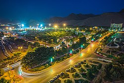
 View of the city | |
| Coordinates: 32°29′13″N 51°23′59″E / 32.48694°N 51.39972°E[1] | |
| Country | Iran |
| Province | Isfahan |
| County | Lenjan |
| District | Fuladshahr |
| Arya Shahr | 1964 |
| Elevation | 1,700 m (5,600 ft) |
| Population (2016)[2] | |
• Total | 88,426 |
| Time zone | UTC+3:30 (IRST) |
| Area code | 031526 |
| Website | kfis |
Fuladshahr (Persian: فولادشهر)[a] is a city in, and the capital of, Fuladshahr District of Lenjan County, Isfahan province, Iran. It is also the administrative center for Khorram Rud Rural District.[4]
Demographics
[edit]Population
[edit]At the time of the 2006 National Census, the city's population was 55,496 in 13,822 households, when it was in the Central District.[5] The following census in 2011 counted 66,903 people in 18,615 households.[6] The 2016 census measured the population of the city as 88,426 people in 26,631 households.[2]
After the census, Fuladshahr was separated from the district in the establishment of Fuladshahr District.[4]
Overview
[edit]The city is 25 kilometres (16 mi) south of Isfahan and about 100 kilometres (62 mi) north of Shahrekord. It was built during the Shah of Iran period, and was home to the mostly Russian and other employees of the Zob Ahan factory, located near the city. The world's third-largest cement factory at the time, the Siman Sepahan Dizicheh or Siman Arya Dizicheh as it was called before the Iranian revolution, is also near the city.
Sports
[edit]
Fuladshahr is home to Fuladshahr Stadium, the permanent home of Zob Ahan.
See also
[edit]Notes
[edit]References
[edit]- ^ OpenStreetMap contributors (19 June 2023). "Fuladshahr, Lenjan County" (Map). OpenStreetMap (in Persian). Retrieved 19 June 2023.
- ^ a b "Census of the Islamic Republic of Iran, 1395 (2016)". AMAR (in Persian). The Statistical Center of Iran. p. 10. Archived from the original (Excel) on 19 October 2020. Retrieved 19 December 2022.
- ^ Fuladshahr can be found at GEOnet Names Server, at this link, by opening the Advanced Search box, entering "6013401" in the "Unique Feature Id" form, and clicking on "Search Database".
- ^ a b Rahimi, Mohammad Reza (1 April 2013). "Approval letter regarding country divisions in Isfahan province". Islamic Council Research Center (in Persian). Ministry of Interior, Council of Ministers. Archived from the original on 10 July 2013. Retrieved 18 June 2023.
- ^ "Census of the Islamic Republic of Iran, 1385 (2006)". AMAR (in Persian). The Statistical Center of Iran. p. 10. Archived from the original (Excel) on 20 September 2011. Retrieved 25 September 2022.
- ^ "Census of the Islamic Republic of Iran, 1390 (2011)". Syracuse University (in Persian). The Statistical Center of Iran. p. 10. Archived from the original (Excel) on 17 January 2023. Retrieved 19 December 2022.


