Lame Deer, Montana
Lame Deer, Montana
Meaveʼhoʼeno | |
|---|---|
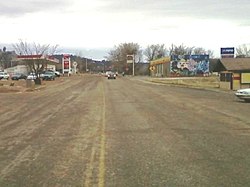
 Looking south on Cheyenne Ave near the center of town. | |
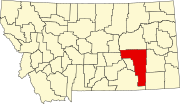
 Location of Lame Deer, Montana | |
| Coordinates: 45°37′23″N 106°40′01″W / 45.62306°N 106.66694°W | |
| Country | United States |
| State | Montana |
| County | Rosebud |
| Area | |
• Total | 55.59 sq mi (143.99 km2) |
| • Land | 55.59 sq mi (143.99 km2) |
| • Water | 0.00 sq mi (0.00 km2) |
| Elevation | 3,865 ft (1,178 m) |
| Population (2020) | |
• Total | 1,897 |
| • Density | 34.12/sq mi (13.17/km2) |
| Time zone | UTC-7 (Mountain (MST)) |
| • Summer (DST) | UTC-6 (MDT) |
| Area code | 406 |
| FIPS code | 30-42250 |
| GNIS feature ID | 2408567[2] |
Lame Deer (Meaveʼhoʼeno in Cheyenne[3]) is a census-designated place (CDP) in Rosebud County, Montana, United States. The community is named after Miniconjou Lakota chief Lame Deer, who was killed by the U.S. Army in 1877 under a flag of truce south of the town.[4] It was the site of a trading post from the late 1870s.[5]
It is the tribal and government agency headquarters of the Northern Cheyenne Indian Reservation. This is the location of the Chief Dull Knife College and the annual Northern Cheyenne Powwow.
Geography
[edit]According to the United States Census Bureau, the CDP has a total area of 55.6 square miles (144 km2), all land.
Climate
[edit]According to the Köppen Climate Classification system, Lame Deer has a semi-arid climate, abbreviated "BSk" on climate maps.[6]
Demographics
[edit]| Census | Pop. | Note | %± |
|---|---|---|---|
| 2020 | 1,897 | — | |
| U.S. Decennial Census[7] | |||
| Languages (2000) [8] | Percent |
|---|---|
| Spoke English at home | 67.87% |
| Spoke Cheyenne at home | 28.88% |
| Spoke Crow at home | 2.70% |
| Spoke Dakota at home | 0.54% |
As of the census[9] of 2010, there were 2,052 people, 521 households, and 401 families residing in the CDP. The population density was 36.3 inhabitants per square mile (14.0/km2). There are a total of 613 housing units, which makes at an average density of 10.3 per square mile (4.0/km2). The racial makeup was 93.7% Native American, 4.3% White, 0.03% African American, 0.01% Asian, 0.2% from other races, and 1.4% from two or more races. Hispanic or Latino of any race were 3.4% of the population.
Of the 521 households, 40.9% had children under the age of 18 living with them, 36.5% were married couples living together, 26.9% had a female householder with no husband present, and 23.0% were non-families. 19.4% of the households had someone living alone who was 65 years of age or older. The average household size was 3.90 and the average family size was 4.53.
The population was spread out, with 43.7% under the age of 18, 55.1% 21 or older and 5.6% who were 65 years of age or older. The median age was 23.9 years. For every 100 females there were 93.7 males. For every 100 females age 18 and over, there were 95.2 males.[8]
The median household income was $28,700 and the median income for a family was $32,039 43.1% of the population were below the poverty line, including 45.8% of those under the age of 18 and 46.9% of those 65 and older.[8]
Education and culture
[edit]The Northern Cheyenne Arts and Crafts Center, Charging Horse Casino and Cafe, and Lame Deer Museum are located here.[10]
Chief Dull Knife College is a Native American tribal community college and land grant institution located in Lame Deer.
The main office of the National Indigenous Women's Resource Center, which works to prevent family violence, is located in Lame Deer.[11]
The Lame Deer High School Morningstars[12] play in the 3B conference with the Baker Spartans, Colstrip Colts, Forsyth Dogies, St. Labre Braves, and Broadus Hawks.
Media
[edit]The Forsyth-based Independent Press covers news for all of Rosebud County, which includes Lame Deer.[13]
References
[edit]- ^ "ArcGIS REST Services Directory". United States Census Bureau. Retrieved September 5, 2022.
- ^ a b U.S. Geological Survey Geographic Names Information System: Lame Deer, Montana
- ^ "Cheyenne Dictionary". Chief Dull Knife College.
- ^ Lame Deer, Seeker of Visions by John Fire, Richard Erdoes, p. xxiii
- ^ "Lame Deer". Montana Place Names Companion. Montana Historical Society. Retrieved April 5, 2021.
- ^ Climate Summary for Lame Deer, Montana
- ^ "Census of Population and Housing". Census.gov. Retrieved June 4, 2016.
- ^ a b c "Community Facts". Retrieved March 7, 2014. "Community Facts" American FactFinder, United States Census Bureau
- ^ "U.S. Census website". United States Census Bureau. Retrieved January 31, 2008.
- ^ "Northern Cheyenne Indian Reservation". Northern Cheyenne Indian Reservation. Archived from the original on October 1, 2014. Retrieved November 2, 2014.
- ^ "Lame Deer woman works nationally to end violence against Native females". Retrieved November 2, 2014.
- ^ "Member Schools". Montana High School Association. Retrieved April 19, 2021.
- ^ "Home page". Independent Press. Retrieved September 22, 2023.
External links
[edit]![]() Media related to Lame Deer, Montana at Wikimedia Commons
Media related to Lame Deer, Montana at Wikimedia Commons
- Northern Cheyenne Tribe
- Lame Deer Flag Song and translation (sound files)

